Istor-o-Nal, North I
24,288
7,403
May, June & July
J.E. Murphy and T.A. Mutch
1955
Extreme
Professional
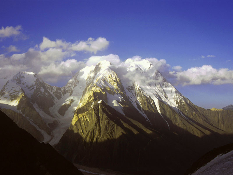
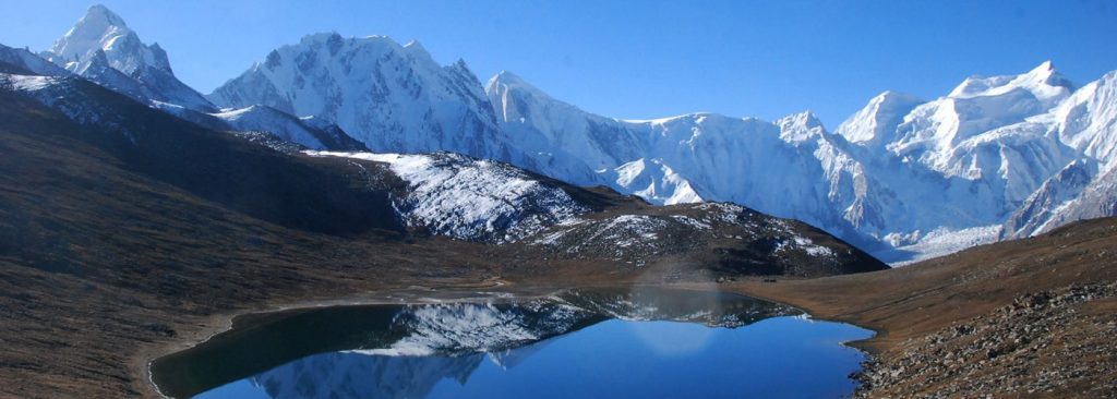
lstoro-o-Nal (Main); This is the highest peak of lstoro-o-Nal range (7,403m/7,398m – 24,288ft/24,271ft) and is situated near the south Udren (Atak) glacier. It is believed that the peak was climbed in 1955 by two members of an American expedition party namely J.E. Murphy and T.A. Mutch. It is now realised that instead, in cloudy weather, the pair mistakenly climbed the highest summit of the ridge between the Rock Pinnacle and lstoro-o-Nal (North).
It was, however, in 1969 that four members of a Spanish expedition of Barcelona Mountaineering Club party climbed it by traversing south of the main peak of the south peak (7303m/23,960ft) and then climbing over the south-east peak (7,365m/24,163ft) to the main peak (7398m/24,271ft). Quite a few maps, including Japanese, indicate its height as 7,403m /24,288ft.
The second highest peak in the range is lstoro-o-Nal (North-I-7,373m/24,190ft). It was climbed in 1967 by Lapuch and Oberegger of the Salzburg Section of the Austrian Alpine Club. While descending from the mountain, Oberegger broke his leg at 6,797m/22,300ft. and was carried down with the help of porters who were working with a Czech expedition. The party shows height of the peak as 7,248m/23,779ft.
The third highest peak in the range is lstoro-o-Nal (N-II), with a height of 7,372m/24,186ft. After climbing lstoro-o-Nal (N-I), as stated above, the members of the Salzburg Section of the Austrian Alpine Club climbed this peak in 1967. The party states that this peak is slightly lower than lstoro-o-Nal (N-I). The party is, however, silent on the exact height of the peak. Japanese maps show its height as 7,372m and 7,350m, respectively.
The next and the fourth highest peak in the range is lstoro-o-Nal (SE) with a height of 7,365m/24,163ft. It was in 1969 that members of Barcelona Mountaineering Club (Spain) climbed it. Names of members of the expedition are: Mose-Manuel Anglada, Juan Cerda, Emiho Civio and Jorge Pons.
The fifth highest peak in the range is lstoro-o-Nal (South) 7,303m/23,960ft. The peak was climbed by the above stated Spanish party in 1969 while on its way to lstoro-o-Nal (South-east). The sixth peak in the range, as shown by Japanese maps, is lstoro-o-Nal (West-I) with a height of 7,300m/23,950ft. Another nearby peak, which is also shown by the Japanese maps, is named lstoro-o-Nal (North-III) with the same height (7,300m/23,950ft). It is for the future mountaineers to clearly identify this peak. This is the seventh peak of the range.
The eighth and ninth peaks in the range are lstoro-o-Nal (West-II) (7,280m/23,884ft) and lstoro-o-Nal (North-east) (7,276m/23,871ft), respectively. The tenth highest peak in the range is a rock pinnacle with a height of 7,200m/23,622ft. It was also climbed in 1969 by members of the Spanish Mountaineering Club when they climbed the lstoro-o-Nal (South-east) and South peaks. Some publications indicate that it was climbed in 1955 by an expedition from the United States of America.
The eleventh peak in the range, as identified by the Japanese maps, is lstoro-o-Nal-East with a height of 7,100m/ 23, 294ft.